Muttock-Pauwating Site: Previous Research
An archaeological Data Recovery was conducted at the seven lots at the project area in Middleborough, Massachusetts under a permit granted by the Massachusetts Historical Commission (MHC). Previously conducted Site Examination testing at the project area occurred in 2004. Testing occurred at eight proposed house lots, two proposed cul-de-sacs and two drainage basin locations. Testing confirmed that site 19-PL-292, the Muttock-Pauwating site, is a large, complex Native archaeological site with a high degree of integrity and a large variety and high density of artifacts and subsoil features. Artifacts were found that dated predominantly to the Late Archaic and Woodland periods with evidence of a smaller Middle Archaic occupation also present.
Seven of the eight house lots and one of the cul-de-sacs investigated were found to have high densities of artifacts and features. The Site Examination determined that the Muttock-Pauwating site meets the criteria for listing in the State and National Registers of Historic Places under Criterion D of the National Register (36 CFR 60) and under Criterion A for its association with the Woodland Period in southeastern New England. National Register eligibility was based on the following reasons:
1) The site is generally in undisturbed condition, and has its highest concentration and intact
features within the undisturbed subsoils, and thus appears to have a high degree of
integrity. Thus the site has clarity of data and has not been disturbed historically.
2) The site represents discreet areas where a variety of Native American activities- including tool manufacture, tool maintenance, habitation, cooking and resource procurement-took place. Therefore, the site has the potential to provide information that concerns tool use and
manufacture, and subsistence activities, which rarely have been scientifically investigated at other archaeological sites in the region.
3) Local and non-local provided the raw materials for tool manufacture from the Muttock-Pauwating site. While quartz and quartzite are locally available in many locations in the immediate area, rhyolite sources may have required travel or trade to neighboring areas, such as the Attleboro area, or the Boston Basin. The study of the sources of raw materials used in the region at different times in prehistory, or at different kinds of sites, is basic to our understanding of subsistence strategies and regional interaction spheres of the Native American populations. Thorough investigation of the sites and comparison of the contents with those from other sites in the area can provide valuable information to help us understand the cultural traits that enabled this pattern of use.
4) The site has multiple cultural components that span a period of over 7,000 years of history. These multiple components document changes in the broad patterns of history that occurred during the Native American past. The presence of numerous features indicates that the multiple components can be isolated into discrete entities that can aid in understanding the past.
Previous Research
Avocational archaeological investigations at the three sites located partially or completely within the project area have occurred sporadically over the past 100 years. Identification of the Muttock-Pauwating site, 19-PL-292, in the eastern part of the project area, took place in the early twentieth century. Excavations by the Middleboro Archaeological Society in the 1930s reportedly found little or nothing at the site. Excavations were also conducted by the Massachusetts Archaeological Society in the 1950s-60s. Research conducted for the Intensive survey and Site Examination included an interview with one of the participants of these tests, Don Gammons. Gammons related that excavations conducted on the terrace above the river in what is now the southern part of Lots 7 and 8, resulted in the recovery of a large number of artifacts, including several unfired clay balls, which may have been clay stock for artifacts, including evidence of pottery manufacture (Donta 2006). The river site, 19-PL-421, lies in the northwestern part of the project area, south of north end , and east of the power lines with one stone ax being recovered here (Johnson and Mahlstedt 1984). The Wood site, 19-PL-726, in the south-central part of the project area where avocational collecting at the site has yielded projectile points from the Middle Archaic through the Late Woodland periods as well as other stone tools such as atlatl weights, drills, stemmed and stemless knives, end and side-scrapers, pestles, an adze, grooved axes, a hammerstone, pendants, and steatite.
Summary of Intensive Survey Testing
The proposed Intensive Survey consisted of 72 50 x 50 cm shovel test pits, divided between two survey units. Survey Unit 1 encompassed six house lots in the northern half of the project area, and Survey Unit 2 included six house lots in the southern half. Field methodology proposed eight judgmentally placed test pits, should they be needed to confirm the location of archaeological sites. The actual testing excavated 64 of the recommended 72 STPs, as well as a 1 x 1 m unit that encompassed one of the STPs.
Fifty-seven of the 64 STPs produced Native American artifacts, and 22 contained subsoil features. Testing recovered a total of 1,496 Native American artifacts from both the plowed topsoil and the underlying, undisturbed subsoil. Artifacts recovered included 25 lithic tools, 387 pieces of pottery, one piece of worked metal, and a large amount of chipping debris and fire-cracked rock. Projectile points recovered included Late Archaic (Brewerton Eared-Notched, Atlantic, Squibnocket) and Late Woodland (Levanna and Madison) varieties. Substantial amounts of recovered pottery indicated a potentially large Woodland Period component within the site. It also indicated a larger and more permanent type of site, such as a base camp or habitation site.
Summary of Site Examination Testing
Previous testing designed the Site Examination testing to gather more information about soil stratigraphy, artifact density, and subsurface features. The research design proposed a grid pattern of 180 shovel test pits and 22 excavation units 1 x 1 m in size to investigate features. Due to a greater depth required than expected in many of the 1 x 1 m units, and a larger number of features found than expected, the completed field testing amounted to 175 shovel test pits and 17 excavation units.
Field investigations recovered a total of 6,070 Native American artifacts, the majority (n= 4530) of which was chipping debris from stone tool production. One hundred and nineteen lithic tools, consisting of projectile points dating from the Middle Archaic to Late Woodland periods, point fragments, along with bifaces, cores, hammerstones, scrapers, drills, and ground stone were also recovered. Along with the stone tools were 920 fragments of pottery, and 501 pieces of fire-cracked rock and many fragments of calcined bone. Quartz was the predominant raw material used, followed by rhyolite with chert, argillite, quartzite and jasper making up smaller percentages
The highest frequency of Native American artifacts was found in the plow zone, and in the underlying upper part of the subsoil. Field personnel recovered the highest number of Native American artifacts from Lot 6, with around 2,300, followed by Lot 4 at 1,755 artifacts, and then Lot 7 with 585. The highest density of Native American artifacts was found in the western cul-de-sac/Lot 4 area, which had densities of 155 and 193 artifacts per square meter. Lot 6 followed with 145 per square meter, and then Lot 5 (121 per square meter) and Lot 7 (71 per square meter).
Site Examination testing investigated 69 Native American features, some of which were first found during the Intensive Survey. Lot 6 yielded 21 features, the largest number encountered in a lot, followed by Lot 7 (18), Lot 4 (11), and Lot 8 (7). The features include fire pits, storage and/or trash pits, living surfaces, one human burial, post molds, and middens. The following section describes the features found and their associated artifacts, organized by proposed impact location.
Western Cul-de-Sac
Field crews excavated a total of 11 shovel test pits, four during the Intensive Survey and seven during the Site Examination, along with one 1 x 1 meter excavation unit, in the area of the proposed road cul-de-sac in the western part of the project area. Identified were a total of three features (Features 11, 39 and 40). Features included a probable hearth containing pottery (Feature 11) and two postmolds (Features 39 and 40). Artifacts recovered consisted of 545 Native artifacts including one Late Woodland Levanna point, one untyped point, rhyolite and quartz cores, 57 fragments of pottery, fire-cracked rock and calcined bone fragments.
Final analysis considered the remains recovered in the Western cul-de-sac potentially significant and the final report recommended that a Data Recovery survey be completed to mitigate the loss of this resource if this site cannot be avoided by construction.
Lot 3
Lot 3 was not tested during the Intensive Survey. The Site Examination research strategy proposed 11 shovel test pits for this lot. Fieldwork excavated nine test pits in a grid pattern in the proposed location of the house and septic system. Field crews recovered a total of 47 Native artifacts including 42 quartz and rhyolite flakes and five possible cores. Field testing did not identify any diagnostic artifacts or features.
The final report interpreted Native use of this lot as being ancillary to the larger occupation encountered in lots 4 through 8. It concluded that, due to the low artifact density and the lack of diagnostic artifacts, this area was not considered potentially significant. The recommendation was for no further testing be completed in the Western drainage basin.
Lot 4
Field crews excavated 33 shovel test pits and five 1 x 1 meter excavation units during the Intensive Survey (n=11 STPs) and Site Examination (n=24 STPs and 5 Eus) in Lot 4 resulting in the identification of 13 features (Features 4, 8, 9, 18, 19, 27, 28, 30-34, 37). The features included five pits (Features 4, 8, 33, 34, 37), one hearth (Feature 9), one Native human burial (Feature 32), and six postmolds (Features 18, 19, 27, 28, 30, 31). Feature 4 was found to lie within the 200 foot riparian zone and was not further tested. Fieldwork testing recovered a total of 2460 Native artifacts from this lot. Artifacts include one Late Woodland Levanna point, at least nine untyped points, rhyolite and quartz cores, preforms, bifaces, scrapers, ground stone, a knife fragment, hammerstone, abrading stone, 174 fragments of pottery, fire-cracked rock and shell and bone fragments. The artifacts represent the remains of a potentially significant settlement site, such as a seasonally occupied camp, where inhabitants erected structures, lit fires, and excavated and filled pits used for burial, storage and refuse disposal. The final report concluded that based on the recovery of many artifacts in undisturbed soils in association with multiple intact features, significant resources existed in Lot 4. Researchers recommended that a Data Recovery survey be completed to mitigate the loss of this resource if this site cannot be avoided by construction.
Lot 5
Field testing excavated a total of 17 shovel test pits, four in the Intensive survey and 13 in the Site Examination, and one 1 x 1 meter excavation unit in Lot 5. Intensive Survey testing identified three features, all pits, (Features 5, 6 and 7). These features were not further investigated as it was found that they lay within the 200 foot riparian zone and thus would not be affected. Site Examination fieldwork encountered one other feature, (Feature 38), which was also a pit. Field crews recovered a total of 635 Native artifacts from Lot 5. These include an untyped rhyolite point fragment, a rhyolite biface, two quartz bifaces, and two quartz cores, along with 27 fragments of pottery, fire-cracked rock and bone fragments.
Based on the recovery of numerous artifacts in undisturbed soils, associated with multiple intact features, researchers considered the Native American resources within the Lot 5 significant. Multiple other features are likely to exist in and around the areas proposed for impacts. These features and associated artifacts are valuable in understanding the nature of the Native American occupation of the Middleborough area over the past 3,000 or more years. The final report recommended that if this site cannot be avoided by construction that a Data Recovery survey be completed to mitigate the loss of this resource.
Lot 6
Field testing excavated a total of 43 test pits, eight during the Intensive Survey and 35 during the Site Examination, and seven excavation units, all excavated during the Site Examination, in Lot 6. The identification of 22 features (Features 12, 13, 14, 15, 16, 41, 42, 46, 47, 49, 51, 52, 59, 60, 61, 76-82) including one pot drop (Feature 12), three living surfaces (Features 13/ 15, 46, 60), four pits (Features 14, 51, 52, 61), two pit hearths (Features 41, 47) and 11 postmolds (Features 16, 42, 49, 59, 76-82) indicating a significant Native presence in this lot. Several of the test pits and features fell within the 200 foot riparian zone next to the river and as a result were not recommended for further investigation. Field crews recovered 2500 Native artifacts including 46 stone tools, along with 635 fragments of pottery, 266 pieces of fire-cracked rock and bone and shell fragments. Projectile points recovered dated to the Middle to Late Archaic. The recovered pottery indicates Woodland period occupation.
The final report considered Lot 6 as having the potential to yield significant information about Native life ways in the pre-Contact period. Researchers recommended that if this lot could not be avoided by construction, a Data Recovery survey be completed to mitigate the loss of this resource.
Lot 7
Field testing excavated a total of 36 shovel test pits, nine during the Intensive Survey and 27 during the Site Examination, and two 1 x 1 meter excavation units, both during the Site Examination, in Lot 7. The proposed testing for the Site Examination included 29 test pits and three excavation units. Field crews recovered 777 Native artifacts consisting of 10 stone tools including one Early Woodland Rossville point, 12 fragments of pottery, 28 pieces of fire-cracked rock, and bone fragments. Testing identified 18 features in Lot 7 (Features 17, 20, 21, 25, 48, 53-58, 67-73). Five of these features (Features 69-73) were layers of fill within a pit feature (Feature 54). Other features included two hearths (Features 20, 58), three pits (Features 17, 21, 57), two living surfaces (Features 53 and 56), four postmolds (Features 25, 48, 55, 67) and one rock cluster (Feature 68).
The final report considered Lot 7 as having the potential to yield significant information about Native life ways in the pre-Contact period. Researchers recommended that if this lot could not be avoided by construction, a Data Recovery survey be completed to mitigate the loss of this resource.
Lot 8
Testing consisted of a total of 24 test pits, four during the Intensive Survey and 20 during the Site Examination, as well one 1 x 1 meter excavation unit during the Site Examination, in Lot 8. Field crews identified seven features (Features 23, 24, 62-66) including five pits (Features 23, 62, 64, 65, 66), one deposit of pit fill (Feature 24) and one living surface (Feature 63). The also recovered 275 Native artifacts including a projectile point fragment and core, 72 fragments of pottery, 21 pieces of fire-cracked rock, bone fragments and fragments of lithic chipping debris.
The final report considered Lot 8 as having the potential to yield significant information about Native life ways in the pre-Contact period. Researchers recommended that if this lot could not be avoided by construction, a Data Recovery survey be completed to mitigate the loss of this resource.
Eastern Drainage Basin
The Eastern Drainage Basin was not tested during the Intensive Survey. The research design for the Site Examination proposed 14 shovel test pits for this area during the Site Examination with 13 being dug. Field crews recovered 40 Native artifacts including a quartz triangle projectile point, and a second untyped point, one piece of fire-cracked rock, and 38 pieces of chipping debris. They did not encounter any features.
The final report recommended no further archaeological testing for this area due to the low density of cultural material and the lack of features.
Previous Testing Artifact Analysis
Previous testing Archaeological Services conducted the artifact analysis of the material recovered from the Intensive Survey and Site Examination testing. Analysis identified the materials, use and date of manufacture for as many artifacts as possible.
Lithic Debitage
Debitage associated with the manufacture of lithic tools (flakes, shatter, cores) and tools resulting from that manufacture (points, bifaces, scrapers, choppers) make up the largest category of artifacts recovered from any of the lots (Table 1). A total of 6,581 out of the 8,358
 recovered artifacts were stone with the largest percentage of these (67.7%) being flakes and shatter. Other stone artifacts recovered included 779 pieces of fire-cracked rock and 145 tools or tool fragments.
Recovered artifacts included a variety of materials, both those that could have collected from the local area (local lithics) such as quartz, quartzite, argillite, mudstone, siltstone, sandstone, granite, and possibly rhyolite, and materials that would have arrived at the site through trade or collection from locations farther afield. The latter class includes hornfels, possibly from the Blue Hills outside of Boston (local exotics), jasper, possibly from Pennsylvania, and chert from New York State (far exotics). Previous testing recovered many of the raw materials from the lots investigated during the Data Recovery (quartz, quartzite, rhyolite, chert), while the rest were more sporadic in their occurrence. It is not known if occurrence of certain material types in only certain lots is temporally related, if it is a result of sampling strategy, or if other factors are at work.
At 81.6% of the total assemblage, quartz made up the highest percentage of lithic raw material debitage recovered, followed by rhyolite at 13.5%, basalt/ hornfels ( 1.6%), chert (1.1%), quartzite (.9%), jasper (.2%) and argillite (.2%). Rhyolite was gray, purple, dark red, black and brown in color, varieties that are common in the Boston Basin area. The likely source for the raw material for these stones was as river or glacial cobbles recovered from the river banks. The lithic assemblage was primarily local sources (local lithics) with some possible trade with the Boston Basin (local exotics) and farther to the south and west (far exotics) occurring.
Tools
The lots with the largest artifact assemblages, Lots 4 and 6 yielded the widest variety of lithic tool types (Table 2). The variety of tool types recovered is indicative of the types of activities
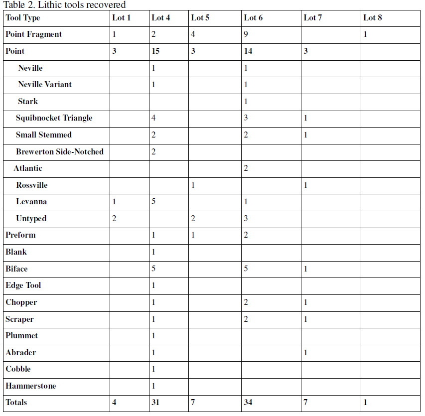 carried out at that site. Every lot had projectile points or projectile point fragments, indicating that the production, retouching and use of projectile points were activities practiced by all the people who contributed to the assemblage across the project area. Other tools such as scrapers, abraders and choppers, were only recovered from a few of the lots, possibly indicating that the occupations in these areas consisted of a wider range of activities than elsewhere. Unlike the debitage component of the assemblage, the raw materials consisted of quartz (40.2%), rhyolite (34.6%), quartzite (5.6%), chert and jasper (4.7%), argillite (2.8%) and basalt/ hornfels (2.8%). Donta and Wendt interpreted the more equal occurrence of quartz and rhyolite in the finished tool forms as indicative of substantial contacts among Algonquian-speaking peoples for trade purposes with established mechanisms for obtaining source materials from Northern New England (Donta and Wendt 2006:81). Unfortunately, this theory fails to take into account the rhyolite cobbles in glacial drift deposits within the local catchment area as a possible source for some of the rhyolite raw material. Investigation of cortex-bearing flakes is one way to determine if locally derived cobbles were a source for at least part of the rhyolite raw material.
Pottery
The pottery fragments from the lots investigated during the earlier surveys showed an uneven distribution between lots. Most of the fragments came from lots 4 and 6 with smaller amounts being recovered from the remaining five lots (Table 3). Due to its fragile nature, pottery is
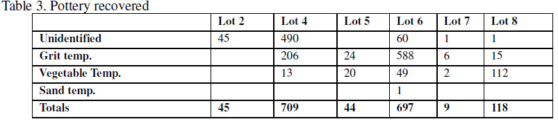 often taken as a sign of extended, sedentary habitation of a site. The concentrations of pottery in lots 4, 6 and to a lesser degree Lot 8, show that these lots were the habitation foci of occupation at the site with the remaining lots possibly representing satellite refuse disposal or scatter caused by plowing and cultural processes.
Previous testing researchers identified three types of temper among the fragments from the site: grit, vegetable and sand. Sand temper was only found on one fragment, grit and possible vegetable temper, were found on the remaining fragments. The sand temper is finer grit temper. Grit temper is very common in New England pottery, but vegetable temper is not as commonly identified. Vegetable, also known as fiber, temper, has been more commonly identified from the southeastern United States where it has been found to date as early as the Late Archaic.
Faunal Remains
The faunal remains from the project area showed a definite uneven distribution between the lots (Table 4). Lot 4, 6 and seven yielded the greatest number of fragments as well as the
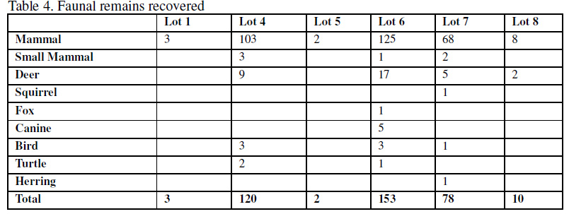 widest variety of species. Bone fragments likely show sites where the processing, consumption and disposal of animal resources took place. The faunal distribution correlates with that of the pottery remains, the likely vessels used to process some of these faunal resources, except in the case of Lot 1 which had no pottery, Lot 2, where no faunal remains were found but pottery fragments were found and Lot 8 where a limited amount of faunal remains were found but pottery was fairly abundant (n=118). Shellfish remains were recovered from lots 4, 6 and 8 with Lot 6 yielding the greatest number of fragments (Table 5).

Previous Testing Feature Analysis
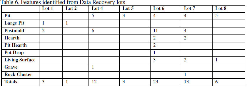
Earlier testing identified a total of 61 features (fill layers within features excluded) in the lots that will be the subject of the Data Recovery investigations (Table 6). Postmolds, possibly
associated with houses or with racks outside or inside of the houses, and pits of undetermined uses, were the most common features identified. Other features included living surfaces, one grave, one rock cluster, hearths, one burial and two large pits. A large number of features at a site is indicative of prolonged habitation of an area and of a variety of activities being performed at such a site. Sites with features such as postmolds, hearths and pit features spread across a wide area suggest nucleated settlement possibly indicative of either village locations or at least sites that were repeatedly seasonally occupied for an extended part of the year.
[button] Back to Historic Context[/button] [button color=”green”] Forward to Data Recovery Research Design[/button]